
Science of the Uinta Basin
The Uinta Basin
The Uinta Basin of northeastern Utah has the most complete interval of the middle Eocene exposed and, in contrast to what we know about the early and late Eocene, also has the least amount of information regarding fossil vertebrates, paleobotany, and paleoclimate. There has always been a gap in our knowledge about vertebrate evolution during the middle Eocene. The Uinta Basin and the Uinta and Duchesne River Formations, are the key to piecing together the middle Eocene.
The Past: The Eocene Epoch (55-34 million years ago or ‘Ma’) is an excellent laboratory for understanding how global warming has driven extinction and speciation and altered both the abundance and distribution of species. Three hyperthermal events (i.e., global warming) have been shown to have occurred during the already warm Eocene and the first two of these, the Paleocene-Eocene Thermal Maximum (PETM; ca. 56 Ma) and the Early Eocene Climatic Optimum (EECO; 51.5-50.9 Ma) have been correlated with changes in biotic interactions, particularly in mammalian species communities. The last hyperthermal, the Middle Eocene Climatic Optimum (MECO, ~40-39 Ma) was first discovered in the Southern Ocean and then eventually discovered in terrestrial sediments in Italy and recently in Montana. The MECO event increased global sea surface temperatures by 4°C and increased North American continental temperatures by 9°C. The MECO occurred over an approximately 600,000 year period.
Our Future: Global mean surface temperatures could increase by 4°C by 2100 if global greenhouse emissions are not curbed (IPCC estimate) and these estimates change as more research is done on climate forcers and effects of climate on our planet. Our team’s goal is to develop a model showing how vertebrates react to naturally paced hyperthermal event. Our results will then be compared to data on modern vertebrates and their habitats.
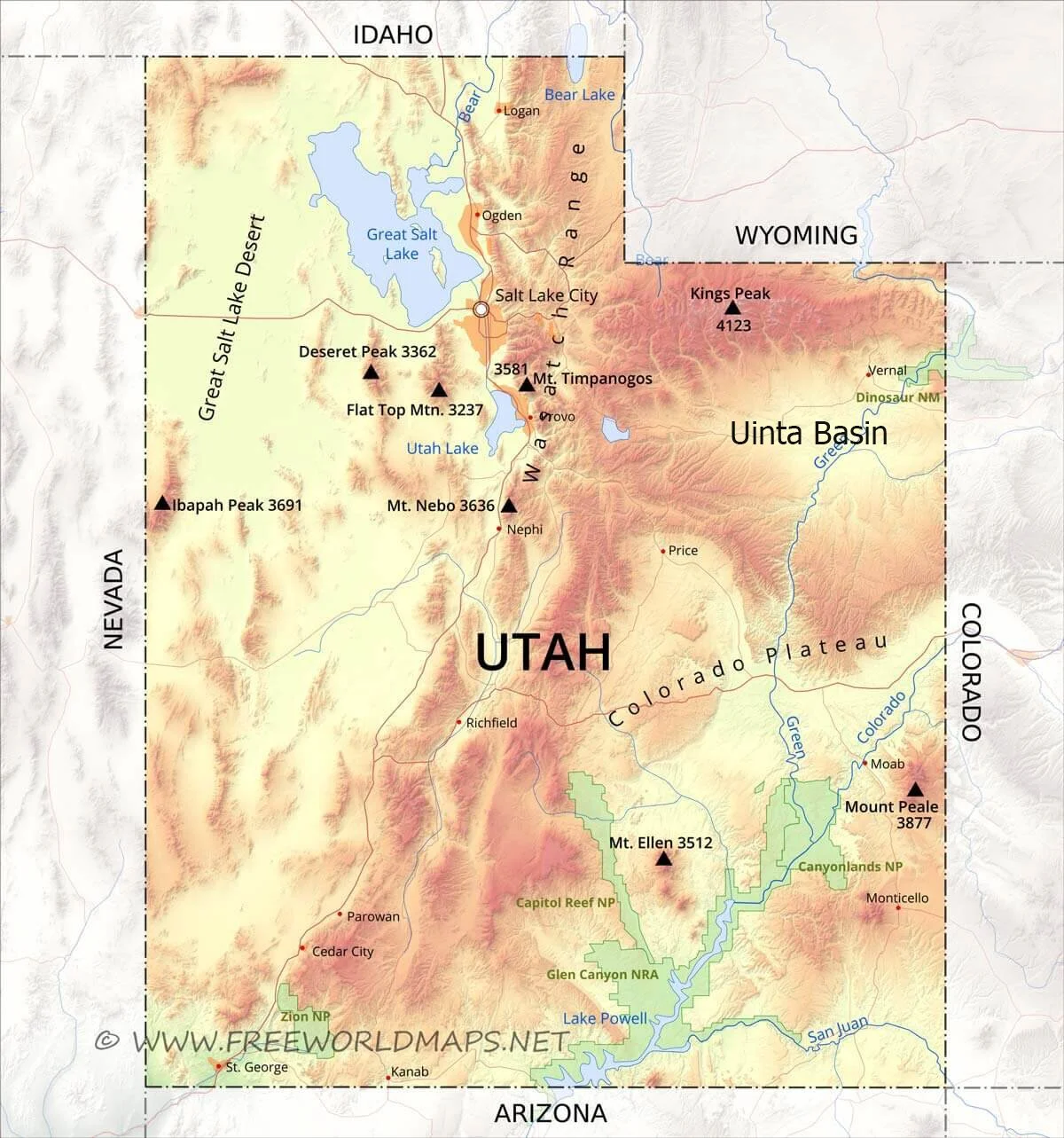
Physical map of Utah showing the Uinta Basin situated between the Uinta Mountains to the north and the Book Cliffs of the Colorado Plateau to the south. The Green River courses through the Uinta Basin on its way to meet the Colorado River in southern Utah. Our study area is south of Dinosaur National Monument in the area between where the White River joins the Green River.
The Rocky Mountain Basins
The Rocky Mountain intermontane basins are famous for their gorgeous exposures and incredible fossil record, particularly for those deposits that record the Tertiary period. During the early Tertiary, the Eocene (55-34 Ma) is characterized by the appearance of the modern orders of mammals appearing in the fossil record (carnivores, primates, rodents, lagomorphs [rabbits], bats, artiodactyls [sheep, cows, antelope], and perissodactyls [horses, tapirs, rhinoceroses]). The early Eocene is well-represented in the Rocky Mountain basins of Wyoming, the later Eocene deposits are more common on the high plains (Nebraska, the Dakotas), and the middle Eocene has been found in spotty areas of Oregon, southern California, and southwest Texas.

The Eocene Epoch
The Eocene epoch spans approximately 55 to 34 million years ago. The early Eocene has been well-studied and early Eocene deposits continue to produce incredible fossils and data about past environments. By comparison, there is much less known about the middle Eocene, particularly the time periods known as the Uintan and Duchesnean North American Land Mammal Ages (NALMAs). Biochronology uses fossils to correlate time and land mammal age is an interval of time that is defined by a group of animals unique to that time period. Land Mammal Ages are used to define time spans in the Cenozoic Era.
We will be using paleomagnetism and detrital zircons to correlate our stratigraphic section in the Uinta Basin with the geomagnetic polarity timescale and to refine where the MECO event occurs in the Uinta Basin.
Map of those Rocky Mountain intermontane basins with Eocene exposures. Map from Gazin 1962, which was adapted from Osborn 1929. The numbers refer to early Eocene localities described in Gazin 1962.

On the left, is the geomagnetic polarity timescale (GMPTS) ranging from the end Cretaceous to the Pleistocene, with epochs divided into European land mammal ages. On the right, is the North American Eocene showing the divisions of the land mammal ages of this continents. The middle Eocene includes the Bridgerian, Uintan, and Duchesnean North American Land Mammal Ages (NALMAs).